This weekend I thought I'd take another trip to the Olympic Peninsula, this time to visit Cape Flattery. Cape Flattery is the most northwesterly point of the Lower 48. The coastline is as you would imagine in to be....rocky, rugged, picturesque.
On the way to Cape Flattery, I was driving through Port Gamble and saw a detachment of individuals in Civil War era uniforms marching alongside the road. This naturally piqued my curiosity so I turned around and saw dozens of white, uniform canvas tents in two separate locations. Come to find out, Port Gamble hosts an annual Civil War reenactment. I asked if they were reenacting the famed Battle of Port Gamble, turning point of the Civil War, but sadly they were just creating scenarios that might have taken place during the Civil War.
I visited both camps and spirits were high. It was around 8:30 a.m., though, and the South was slowly getting moving. I didn't like their chances later in the day. However, they certainly had the cavalry advantage over the Yankees, whose entire mounted forces are shown below. Since the battle wasn't going to get going for another two hours, I had to take off.
The road to Cape Flattery is a lot like the road to Hana on Maui - coastal and twisty. The actual Cape is located in the Makah nation, a Native American reservation comprised of a single town, Neah Bay. Apparently fireworks are legal in this particular Indian Nation because every block (all five or so) had at least two fireworks stands, usually in someone's yard. Whatever supplemental income this provides looks like it is much needed as poverty is pervasive. Neah Bay supported a small (very small) fishing fleet but other than that, there didn't appear to be any industry other than the small amount of tourism the Cape generates.
After hiking out to the Cape, I made the drive to Ozette, an even more isolated town than Neah Bay. Its claim to fame is that it has a pretty nice little lake and it is the westernmost populated are in the Lower 48. During the 21-mile drive from the main road southwest to Ozette, I passed one other car coming the other direction.
All told, I clocked about 370 miles in my Honda Civic FlexCar. This care is my trusted companion. What a deal, too. The firm pays for the membership and for all rental expenses. You basically rent the car for 1/2 hour blocks. The gas is covered in the rental fee, as is the insurance. You just drive it. If you need gas, you use their fleet card. If you lived in a highly-urban area, this would be the only way to go.
If you want to see all of my Seattle/Washington pictures, go to:
http://picasaweb.google.com/margo.beau/SeattleWashington
Some may be redundant or not rotated properly, and hardly any are labeled yet.
All for now.
Subscribe to:
Post Comments (Atom)
Time Capsule

Downtown Astoria
Top of the World
Better slow your mustang down
Nicer than 19th and H

Lewis and Clark Law School
Laying Down the Law

Trina's Grandpa
Co-Founders of the DBC

Bill and Dave's Excellent Adventure
End of the Road

Lews & Clark's Final Campsite
The Mighty Columbia River

Roll On Columbia!
Lake Crescent

Lake Crescent is part of the Olympic National Forest.
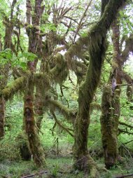
Hoh River

The Hoh River.
Fallen Tree

This is a single fallen tree bordering the trail. It was about 220 feet long.
Sunset

Sunset over Puget Sound.
The Mountain

You can make out Mt. Rainier in the distance.


No comments:
Post a Comment