I took I-90 east from Seattle with the intention of following it to Missoula. Well, about140 miles outside of Seattle I saw a sign that said "Grand Coulee Dam." Well, that was too good to pass up so I took the exit. After all, I had just crossed the Columbia about 10 miles back so I figured they wouldn't put up the sign unless it was close by. I had followed the one-lane road for about 10 minutes wondering why I was getting farther from the river. I checked the map and realized it was about 70-80 miles before I got to the dam. Well, I figured it would add on an extra 2 hours or so to my arrival in Missoula, but, why not? As Margo will also attest, I will look for reasons to go off the interstate if I can. This particular trip was very rewarding, not only because of the majestic things I saw (as you will read about), but also the images of vanishing roadside America. So often when traveling on the interstate, you are insulated from the area by tangled off-ramps and fast food restaurants and seemingly endless gas stations. You get off, refuel, then get back on the elevated highway, never really experiencing the location. I'm not saying that driving through a small town at 25 mph gives one a true feeling for a place, but it sure tells you more than doing 75 mph above and over it. But I digress.
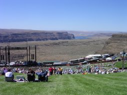
 On the way to the Grand Coulee Dam, I stopped at Dry Falls (in central Washington) - what is thought to be the remnants of the largest waterfall ever on earth. During the last ice age, there was a glacier
dam somewhere around modern-day Missoula. This dam formed a lake which eventually burst the dam and flooded Montana, Washignton, and Oregon (they say Portland was under 300 feet of water. Apparently this happened a coupe of times. They estimate the lake contained 300 cubic miles (yes, miles) of water. A lot of the water ended up going over Dry Falls (not dry then). The falls were 3 miles long and 400 feet high (compared to Niagara Falls' 1 mile and 167 feet). The water was going about 65 miles per hour when it went over the falls. I would recommend checking out the photos on our Picasa site so you can enlarge them.
http://picasaweb.google.com/margo.beau
The folder titled "Seattle" has these pictures; all other folders contain pictures of a very cute baby/toddler.
 There was a visitor center at Dry Falls that I was fascinated by almost as much as I was with the falls. It was built in 1965 and appears to have remained untouched since then, judging from the dioramas. The architecture is also very dated, but that is a good bit of its charm. It's like this little bit of 1965 that the world has moved past. Kind of comforting.
Anyway, after I tore myself away from Dry Falls, I headed towards Grand Coulee Dam. Some of you may be familiar with Woody Guthrie's The Grand Coulee Dam - a song commissioned by the Bonneville Power Authority as part of a PR program. In another song he said that it was"just about the biggest thing that man has ever done." Well, it is pretty big - it is the largest concrete dam (and for that matter, concrete structure) in the United States. Hoover Dam may be more dramatic in appearance, but it isn't bigger. The bottles pictured below were used in the opening of the dam. Water from all of the states and territories was poured over the side by princesses and the queen of the Washington State Apple Blossom Festival.

 Leaving the dam, I finally made for Missoula via Spokane and Coeur D'Alene. I thought once I made it to Couer D'Alene I was getting close, but it was still 170 more miles. I eventually made it then ran into the problem of finding a place to stay. I thought it would be no problem to get a hotel room for the night so I didn't make a reservation before I left. Well, even though the 4th was in the middle of the week, the majority of hotels in Missoula were booked. I finally found one near the University of Montana that had a room available. I told the woman I was coming in 15 minutes and got directions from her. When I got there (15 minutes later) she told me she gave the room away because she wasn't sure I was coming. I expressed my displeasure and left. I was fortunate and found a room in a motel down the street. This motel was even more throwback than the first (see attached picture). In turned out o.k., though. The woman who owned the place was from Salida and lived in D.C. for a while after college. Small world.
 Sunday morning I woke up and had to get on the road fairly early so I could get back to Seattle at a decent time. Before leaving, though, I hiked up Mount Sentinel to the big, concrete "M" on the side of the mountain. This is similar to the Colorado School of Mines' "M" except they don't use this to punish incoming freshmen like they do in Golden. It is not a long hike but it is fairly steep. You are rewarded, though, with a very nice view of the valley.
After the hike, I hit the road for Seattle. I did stop at the world famous "Silver $ Saloon" along the way. It is like a little "Little America." They have an amazing collection of junk for sale. I think they bought all of the inventory from all the Stuckey's around the country that have bitten the dust. Anyway, the reason I stopped (other than morbid curiosity) is that the signs promised they had 10,000 silver dollars. Well, they didn't lie. They actually have 40,000+ silver dollars attached to the walls of their bar area. I guess it would be too much trouble to change all 300 signs in both directions to reflect the more accurate total. Well, nothing could top that so I didn't even try the rest of the way home.
Margo and Quinn Update
This weekend, Quinn had a wheezing attack and was diagnosed with two ear infections and Reactive Airway Disease. Margo has been Supermom this whole time I've been gone, but this illness has made her work twice as hard as she normally does. I thought this picture was particularly cute.


No comments:
Post a Comment